Sign at Trailhead of new Si Trail......Mt. Si Trail 4 Miles, Top Elevation 4,167 feet!!
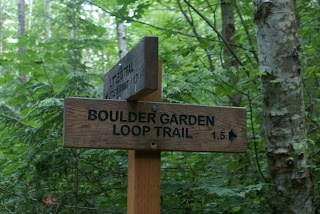
Today Scott and I decided to hike Mt. Si. We took the Little Si Trail to the Boulder Garden Loop Trail which joins up with the start of the Old Si Trail up to the summit. We then followed the New Si Trail back to the trailhead where we picked up Mt. Si road and hiked back to Little Si Trailhead. Today was foretasted for rain, but fortunately it was sunny and clear through out our hike.
Mt. Si is located in North Bend, Washington. It has a top elevation of 4,167 vertical feet. Depending on the clouds, you should be able to pick out nearby Mailbox Peak, Mt. Washington and Rattlesnake Ledge . Mt. Si is quite popular, so if you'd like to experience the beauty of the summit with out the crowds then definitely consider taking the old trail (we only saw two other people on the old trail, compared with dozens on the new).
Of Note: You will notice along the trail some traces of the 1910 fire on Mt. Si which burned for weeks.....today you will notice the new forest of fir trees.
To access the Old Trail, start at the Little Si trailhead. Follow the Little Si trail past the first entrance to the Boulder Garden Loop Trail, to the second split off of the Little Si trail off the the left. If you hit the first stream crossing on the Little Si trail you've gone about 200 feet past the split. Take the Boulder Garden Trail up past the namesake boulders and mossy outcroppings, being watchful for a rough trail leading up to the summit that appears about halfway along the route. This is the Old Trail. At about 3/4 of the way up the trail you'll be able to see the new trail as the two trails almost merge together. But continue up through the trees for about another mile where the Old trail will eventually dead end into the New trail at the rocky section just before the summit.
Driving Directions: From Seattle drive east on I-90 to exit 32 (436th Avenue SE). Turn left (north) over the freeway and drive 0.5 mile to North Bend Way. Turn left (west), and in 0.25 mile turn right (north) on Mount Si Road. Shortly after crossing the bridge, the road banks right. Just after this curve, look for a paved parking area on the left side of the road. This is the Trailhead for Little Si. |


No comments:
Post a Comment